Make of the maps and markings as you like. I cannot explain the markings/legends.
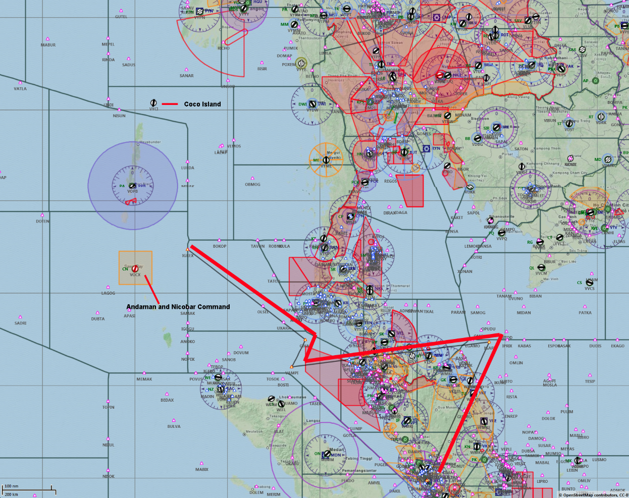
The projected flight path (bold red line in first map) is estimated as the plane was tracked by military radar - Malaysia's and corroborated by Thailand (that such an object/plane was detected by radar). However Thailand claims the aircraft never intruded into Thai airspace, but a straight line from Igari Waypoint to Vampi would have cut into Thai airspace. If Thai statement is true, then the path would not be a straight line.
What we know* timeline
(*or at least have a separate "unidentified official" verification on from a reputable source)
- 1:07 - ACARS last transmission (thru VHF) which apparently includes notation of a WP change having been entered into system since last scheduled report at 12:37
[Update: 23 Mar, official press briefing:
"Update on ACARS transmission
The last ACARS transmission, sent at 1.07am, showed nothing unusual. The 1.07am transmission showed a normal routing all the way to Beijing."
And the Malaysians reverse their statement yet again.]
- 1:11 - INMARSAT ping would have been received. This has some unexplained connection to Boeing's AHM report (thru Satellite?)
- 1:19 - 'Alright, Good Night' at handover (supposedly by co-pilot)
- 1:22 - Transponder goes off
(note: those previous two might be reversed, we have multiple sources seemingly confirming both possibilities. One happened at 1:19, one at 1:22 though. I'm putting them in this order mainly because...)
- 1:22 - Plane goes out of range/black from Thailand Radar (likely from the transponder going black and not the plane going out of range)
- 1:28 - Unidentified plane shows up on Thailand Radar roughly off the Kota Bharu, Malaysia coast (at Malaysia/Thailand border) and this apparently shows plane crossing the Peninsula (without going over Thailand land) to the Straights of Malacca (unknown endtime for this path)
- somewhere between 1:15-1:30 - Vietnam sees plane turn around.
(note: they have not told us a specific time of turn or if they know this because of a Military or ATC radar hit, but they told Malaysia they 'watched plane turn around' sometime shortly after contact was lost)
- roughly 1:30-forward, Vietnam is "frantically" trying to contact the plane
- 1:37 - ACARS misses scheduled transmission
- 1:30-1:45 - at minimum 11 eye witness reports from around and past the Kota Bharu, Malaysia/Thailand border areas (including one saying 'plane descending fast' like one of the later radar hits indicates)
- 2:11 - INMARSAT ping would have been received. This has some unexplained connection to Boeing's AHM report (thru Satellite)
- between 1:30-2:40 - Malaysian Military and Civilian radar picks up an "unidentified" plane flying over peninsula (Daud says "this was corroborated by civilian radar" in the March 9th press conference). Those include a couple radar WP hits we have specifically been told about* (and who knows how many that haven't been provided/leaked):
... VAMPI
... GIVAL
... IGREX
(note: we are not sure of the timing of the radar hits, and there is very contradictory evidence here. The most recent seemingly-official time is 2:15 for the last hit. Which hit that was, we don't know for sure)
- post 2:15/or/2:40 apparent absolute complete blackout of plane (except...)
- 3:11 - INMARSAT ping received. This has some unexplained connection to Boeing's AHM report (thru Satellite)
- 4:11 - INMARSAT ping received. This has some unexplained connection to Boeing's AHM report (thru Satellite)
- 5:11 - INMARSAT ping received. This has some unexplained connection to Boeing's AHM report (thru Satellite)
- 6:11 - IINMARSAT ping received. This has some unexplained connection to Boeing's AHM report (thru Satellite)
- 7:11 - INMARSAT ping received. This has some unexplained connection to Boeing's AHM report (thru Satellite) near 40 Degree line
- 7:24 - Statement released by Malaysian Officials saying contact lost at 2:40 and SAR efforts are underway
- 8:11 - INMARSAT ping received. This has some unexplained connection to Boeing's AHM report (thru Satellite) (thru Satellite) on 40 Degree line
*those way-points on map

(Note on map: the Thailand radar data indicates a straight path from IGARI to VAMPI is not possible ("plane never over Thiland,") so there are more unknown/unreleased turns in there somewhere. Please do not read that map as a 'straight flight' from WP to WP; it was not a straight path over the peninsula, in the very least)
Another Map with Sea depth and projected flight path towards the southern corridor.

Map with the pings to the satellite by time. Because the debris found in the south is within the high probability area, the "ping" tracks is showing the southern path. Note tho, that the ping tracks are estimates and NOT factual. That is, the "ping" tracks were extrapolated based on the assumption that the hypothesis is correct. In other words, the "facts" are being filled in to support the conclusion.

[Update 23 Mar: With all the retraction and corrections, my "belief" or theory is still valid. Contact with the plane was lost at about 1:22 am when the transponder goes off. We do not know if it were switched off deliberately (hijack/terrorism), or as a result of a catastrophic event (explosion, fire, short circuit, etc), or malfunction. The plane subsequently crashes in the the Gulf of Thailand, or disintegrates over it, shortly (say within 30 mins). Likely it crashed more or less intact, and the Immarsat device was still able to transmit. The plane remained afloat or partially afloat until at least 8:11 sending "pings" every hour.]
No comments:
Post a Comment